Tonford Lane (Thanington, Kent)
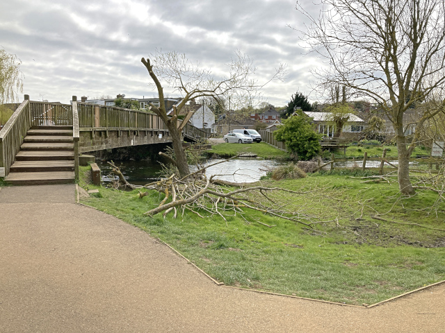
The ford and footbridge across the Great Stour on Tonford Lane
This application was made on behalf of the British Horse Society to Kent County Council under section 53(5) of the Wildlife and Countryside Act 1981 on 6 October 2021 to record part of Tonford Lane as a byway open to all traffic between Tonford Manor Farm and Hassall Reach, Thanington, Kent.
Download the application historical document analysis (24MB), or reduced file size (4.5MB) v.1.0.
Status: application made on 6 October 2021, acknowledged by Kent County Council on 12 October 2021, and recorded in its register of applications as PROW/CC/C476; likely to be reviewed in 2026.
Additional commentary: The public have four remaining years in which to record unrecorded rights of way, before they risk extinguishment in 2026, under Part II of the Countryside and Rights of Way Act 2000. Tonford Lane is one such way which is not recorded on the definitive map and statement held by Kent County Council. It currently is available to pedestrians and cyclists. It would be of use to the longer distance horse-rider who wishes to link the bridleways around Harbledown with those beginning in Larkey Valley Wood, and to the local rider who merely wishes to visit the river. But it is inaccessible, owing to the level crossing being reduced to a pedestrian and cycle crossing. We are not aware of any legal basis for the downgrade.
The purpose of the application is to record the existing public rights on the definitive map and statement. These rights subsist now, and are detailed in the historical document analysis downloadable from this page — if we are wrong about that, the application cannot succeed.
Tonford Lane is shown on the Ordnance Survey map as 'other routes with public access' (shorthand for unsealed public road) and features in the online directory of (purportedly) motorable fords. Our understanding is that there is occasional use by drivers of 4x4s. That it is not more used by vehicles presumably is owing to the difficult approaches, the ford itself, and the railway crossing beyond which is closed to vehicles (and horse riders).
The BHS wishes to protect and secure legitimate access for horse riders and horse-drawn vehicles, and recording Tonford Lane's status on the definitive map and statement is the first step towards securing passage across the railway, because such status, once recorded on the definitive map and statement, is conclusive. It is unlikely that the application, once made, will be determined before 2025, and any order made, if objected to, is unlikely to be confirmed until 2026. If the community wishes to secure Tonford Lane against use by mechanically-propelled vehicles, that leaves some years to seek to have imposed a traffic regulation order to that effect.
It is not the intention of the BHS to open up Tonford Lane to through traffic — which, as use of the lane involves negotiation of a substantial ford with unmade base and approaches, could not in any case be a consequence of the application. The intention is, however, to ensure that Tonford Lane can be used by horse riders and horse-drawn vehicles.